The EdwardRingwald.com Sign Goofs Gallery
After all, we make mistakes sometimes!
Introduction
You know, we pay taxes to build more and refurbish our highways from time to time. However, whenever a road or highway is built or refurbished (such as an asphalt repaving project) signs are either installed and/or replaced as part of a road or highway project. Or, new signs are installed as the need arises.
Our fearless Florida DOT and the Engineering and Traffic Operations departments of Pinellas and Hillsborough counties as well as our three principal municipalities of the Tampa Bay area - St. Petersburg, Tampa and Clearwater - work every day for your tax dollars and at the same time strive for the highest percentage of road sign accuracy as planned for. All the road sign stuff is accurate 99 44/100% of the time, but there is the less than one percent which somehow slips through the cracks and makes it on a street corner or highway near you.
So, I have decided to add another feature here at EdwardRingwald.com dedicated to the less than one percent which somehow slips through the cracks - sign goofs. This will be a feature of its own which I will attempt to keep updated from time to time, so check back here frequently and often for any new sign goofs I may have added.
What follows below is a description of each photo in the sign goofs gallery. Below all the descriptions is the actual sign goofs photo gallery which is keyed to each description.
Descriptions of the photos in the sign goofs gallery
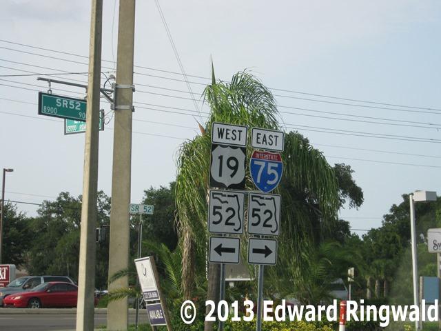
01: US Alternate 19 at Dodecanese Blvd., Tarpon Springs
I came across this sign goof which is looking westbound on Dodecanese Blvd. at the intersection with US Alternate 19. After all, west of US Alternate 19 on Dodecanese Blvd. is Tarpon Springs' famous Sponge Docks along with all the Greek themed shops and restaurants that line Dodecanese Blvd. A good day excursion!
Look very closely at the US Alternate 19 sign in the center. Notice the
type of highway shield used is incorrect - this is an interstate shield which should be an US highway shield instead. If you are
wondering where the real Interstate 19 is, it's a short interstate highway (slightly longer than Interstate 275) in Arizona that
runs between Interstate 10 in Tucson and the Mexican border town of Nogales for a distance of 63 miles according to Andy Field's
Interstate 19 Arizona page.
02: Interstate 75 northbound between Exit 250 (Gibsonton Drive) and Exit 254 (US 301)
While I was taking another day trip on Interstate 75 north on the bypass
route around Tampa, I came across this grammatical sign goof north of the
Alafia River crossing on Interstate 75 northbound.
Look very closely at how the sign is worded. This sign is erected at
every exit ramp in Florida to inform motorists that it does not pay to
litter (Florida Statutes Section
403.413) and that there is at least a $50 fine if you do so. The
sign should read Florida Litter Law $50 Min. Fine For Littering.
Instead, the sign reads Florida Litter Law Fine For $50 Min. Littering
(emphasis added). I presume who fabricated this sign didn't know about
this error that somehow made it onto Interstate 75.
Apparently the signage on this section of Interstate 75 was replaced in
conjunction with a recent repaving and center guardrail installation
project. Typically when a state highway in Florida is repaved the
signage is replaced as needed.
Personally I chuckled when I drove by and noticed the grammatical boo-boo
with the don't litter reminder sign on Interstate 75. 03: The City of St. Petersburg's Municipal Services Center Parking Garage Although our next sign goof I came across takes place in a parking garage
rather than a street or highway, the parking garage attached to the
Municipal Services Center located on One 4th Street North in downtown St.
Petersburg is a public parking garage owned by the City of St. Petersburg.
As the garage is owned by a local government, it qualifies like if it were a
public street for inclusion consideration here at the Tampa/St. Petersburg
Area Sign Goof Gallery. At EdwardRingwald.com, of course!
Take a good look at the signs pointing which way you want to go in the
garage, up one level or down one level. Look very carefully at the
sign for the ramp going up from Level 6A to Level 6B. The sign reads
"down" when in reality the sign should say "up". On the other hand,
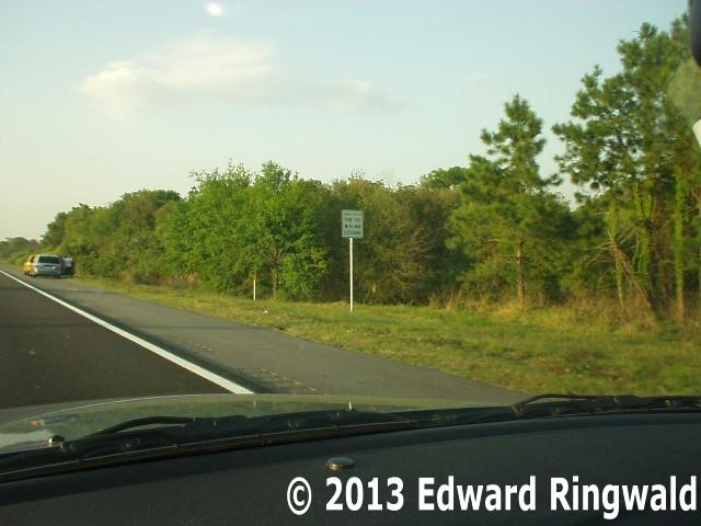
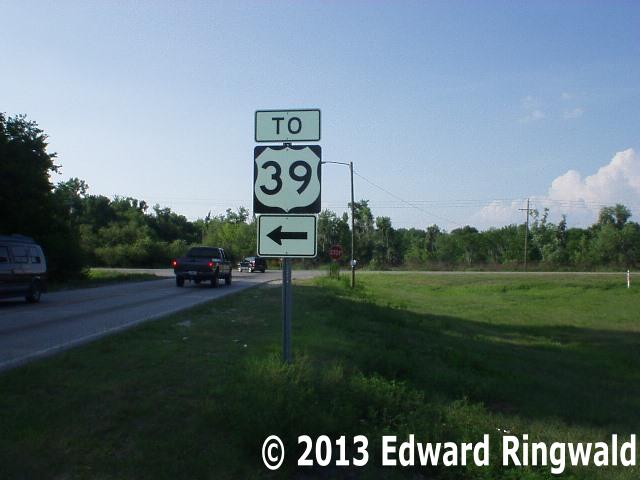
the ramp going down from Level 6A to Level 5B is appropriately signed. 04: Park Road Northbound at Sam Allen Road, Plant City My trusty Saturn and my digital camera paid a visit to the intersection of
Sam Allen Road and Park Road in Plant City. For those of you who don't
know where Plant City is, it's a city with a small town feel to it located
halfway between Tampa and Lakeland on Interstate 4. That's right, the
city which is the home of the annual Strawberry Festival held every year.
As FL 39 (a north-south state highway) passes through Plant City and the
streets of downtown Plant City are narrow, there is signage informing
truckers of the bypass route. Park Road and the section of Sam Allen
Road from Park Road to FL 39 is part of the truck bypass route.
In the picture take a good look at the route shield. This is taken
northbound on Park Road as we approach Sam Allen Road. Those of us
that live in Florida know what the state route shield is, an outline of the
state of Florida which I think is the best of all state route shields in the
United States. The shield that is pictured is completely wrong - the
road number is right (39), but the shield used is the shield for the United
States route marker, which is wrong.
The US routes we have in the Tampa Bay area are US 19, US 92, US 41 and US
301. But we do not have a US 39 in the Tampa Bay area so to
speak. But will the real US 39 please stand up?
Actually, there is no US 39 anywhere to be found in the good old US of A.
A glance at Robert Droz's US
Highways website shows that US 39 is unassigned. But if US 39 is
ever assigned, that's up to the states involved after a submittal to and a
recommendation from
AASHTO's Special Committee on US Route Numbering. After all, a
state can't just put up a US route marker on any ordinary road - it's got to
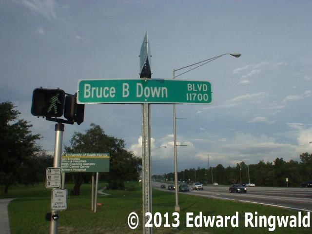
go through the procedures. 05: Intersection of Bruce B. Downs Blvd. and Fowler Avenue (FL 582), Tampa The 4th of July extended weekend in 2006 (it's celebrated on a Tuesday in
2006). Family cookouts. Patriotic pride. Fireworks.
And Star-Spangled sign goofs!
While cruising the north Tampa area around the University of South Florida
main campus as I was turning left from Fowler Avenue (FL 582) onto
northbound Bruce B. Downs Blvd. I came across this sign goof mounted on a
street sign. Look closely at the picture that I took at the northeast
corner of Bruce B. Downs and Fowler; the sign reads "Bruce B. Down" when in
all actuality it should read "Bruce B. Downs". More than likely
the sign was installed by Hillsborough County's Department of Public Works
Traffic Division as Bruce B. Downs Blvd. is Hillsborough County maintained
north of Fowler Avenue; ironically, it's the same agency that installed the
erroneous US 39 sign in Plant City mentioned above. A part of Hillsborough County Road 581, Bruce B. Downs Blvd. begins its
northward journey at Fowler Avenue and turns in a northeastward direction at
Bearss Avenue. Past Bearss Avenue Bruce B. Downs Blvd. runs through
the New Tampa community, which is a community within itself boasting a movie
theater and plenty of various shopping strip malls, not to mention the
numerous residences that are a part of New Tampa. North of New Tampa
Bruce B. Downs Blvd. crosses the Hillsborough-Pasco County line and the
highway becomes Pasco County Road 581 until the intersection of FL 56, where
it changes once more to FL 581 for the remainder of the way to its terminus
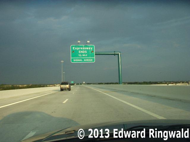
at FL 54 in Wesley Chapel just east of Interstate 75. 06: Eastbound Lee Roy Selmon Crosstown Expressway Express Lanes near Brandon We Tampa Bay area residents read and watch every day with the turmoil going
on at the Tampa Hillsborough County Expressway Authority, especially the
fallout from the collapse of one of the piers of the newly opened reversible
express lanes during construction. Of course it had to be fixed but
there was plenty of finger pointing going on for some time.
My trusty digital camera and I took a side trip on the newly opened
reversible express lanes of the Crosstown Expressway and I came across this
sign goof. Look closely at the
picture, especially the "Signal Ahead" legend on the bottom. The
problem here is that the legend is on a green background when in fact it
should be on a yellow background warning motorists headed in the direction
of Brandon on the express lanes that the Crosstown Expressway is about to
come to an end at the intersection of Brandon Town Center Drive. There
is a sign before this with the correct background as it should be.
Don't forget, this sign has yellow flashers but that's still not enough to
warn motorists.
After all, green signs are for motorist guidance while yellow signs are to
convey a warning to the motorist sayeth the book of the
MUTCD. 07: 22nd Street northbound in Ybor City just south of Interstate 4 in Tampa Ybor City as we Tampa Bay area residents know it is Tampa's historical Latin
quarter. While Interstate 4 is undergoing its big makeover overpass
treatments are being constructed so that the overpasses at Interstate 4's
first exit east of Interstate 275 have a blended in look with the historical
character of Ybor City.
One afternoon my trusty digital camera caught this sign goof on northbound
22nd Street (which is FL 585). Look very closely at the "TO" and the
"WEST" signage just above the shields for Interstate 275 and Interstate 4
respectively. According to MUTCD standards the background color for
signage like this is supposed to be blue as it is part of an interstate
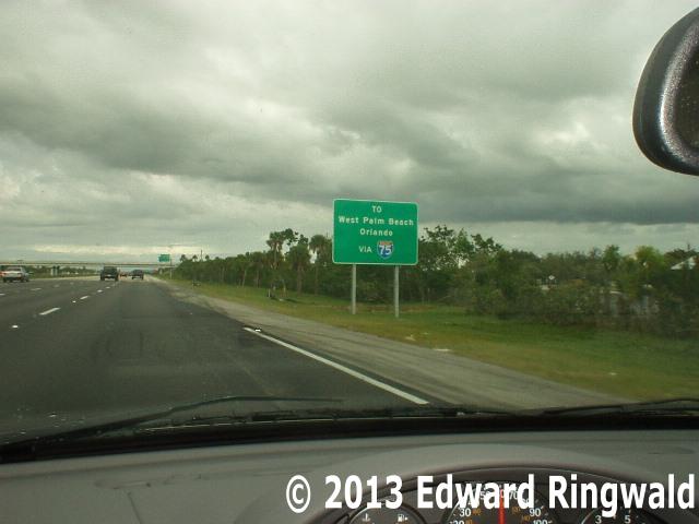
trailblazer assembly. Instead, the background color is white! 08: Interstate 75 northbound before Interstate 595 (Exit 19), Ft. Lauderdale A Thanksgiving weekend 2006 trip to Ft. Lauderdale gave me time to
look around as well as try to update my web sites as I should do, like I
mentioned to students during a recent Great American Teach In a few days
before. However, I came across this (I would say) major sign goof on
Interstate 75 northbound.
Look closely at the sign. It tells you that West Palm Beach and
Orlando are reached via Interstate 75. In actuality, Interstate 75
does not go to these two cities as Interstate 75 meanders north via the
Alligator Alley to Naples as well as St. Petersburg (via Interstate 275) and
Tampa. Instead, the sign should have a FL Toll 869 shield rather
than an Interstate 75 shield as it is FL Toll 869 - known to Ft. Lauderdale
and Broward County residents as the Sawgrass Expressway - takes travelers to
Orlando via a connection to the Florida Turnpike and to West Palm Beach via
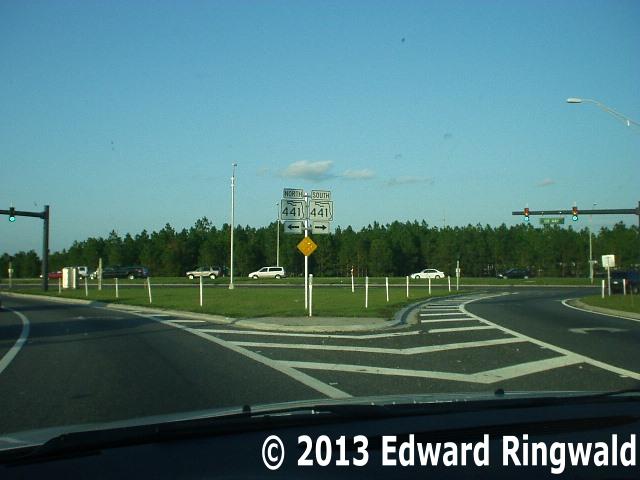
a connection to Interstate 95 on SW 10th Street in Deerfield Beach. 09: US 441 at the northern terminus of FL Toll 429, Orlando The Christmas season is underway and while in the midst of deciding what I
should get for Christmas I did a day excursion to Orlando to explore the
newly completed FL Toll 429 (also called the Western Beltway) from
Interstate 4 to US 441. FL Toll 429 provides a more convenient access
to the Florida Turnpike as well as Apopka (a town northwest of Orlando on US
441). As I approached the end of FL Toll 429 at US 441 I came across
this yuletide sign goof.
Look closely at the two route marker signs. The shields are wrong as
the shield for 441 should be a United States highway shield rather than a
Florida state route shield as pictured. After all, FL Toll 429 ends at
US 441, not FL 441!
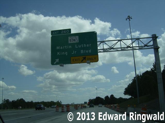
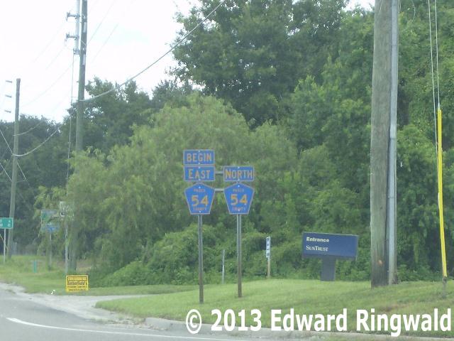
'tis the season for holiday cheer and sign goofs! 10: Interstate 75 southbound at FL 574 (Exit 260), Tampa On a recent reconstruction project on Interstate 75 southbound at Exit 260
(known as FL 574 and Martin Luther King Jr Blvd) the ramp is being widened
from one lane to two lanes to better accommodate traffic especially during
the morning commute. Signage had to be replaced as part of the
project.
Look closely at the way the Exit 260 sign mounted on the top is positioned.
The Manual of Uniform Traffic Control Devices (MUTCD) governs the placement
of exit number signs - called tabs - when mounted on a freeway standard sign
primarily as an aid to the motorist as to what to expect when approaching
the exit. If the tab is placed to the left it communicates a message
that a left hand exit is involved while if the tab is placed to the right it
is a right hand exit. Somehow, the exit number tab was placed on the
top left side of the sign when in fact it should be placed on the top right
side of the sign, as Exit 260 from Interstate 75 south is a right hand exit. 11: US 41 north of Interstate 4 in Tampa As a part of
the Interstate 4 reconstruction project at US 41 (which is Exit 3) overpass
bridges are replaced and new traffic signs and signals are installed to
replace the old. This sign goof was found at the intersection north of
Interstate 4 where US 41 takes a turn to the west and 50th Street continues
northward as FL 583. US 41 northbound reduces from a divided highway
since Naples (being a part of the Tamiami Trail) to a two-lane highway for a
brief segment westward to 40th Street. At 40th Street US 41 becomes a
divided highway once again until it reaches Hillsborough Avenue for a short
multiplex with US 92 to Nebraska Avenue. At Nebraska Avenue US 41
turns north and remains a divided highway until north of Land O' Lakes.
The name of this brief two-lane stretch of US 41 from 50th Street to 40th
Street in Tampa is called Melburne Blvd. Look closely at the spelling
of the street name: Apparently the sign contractor working on the
Interstate 4 reconstruction project got the name wrong and spelled it as
"Melbourne" when the traffic signal was replaced with a Florida-standard
mast arm traffic signal. 12: Morris Bridge Road north of FL 54, Zephyrhills As you know, signs have to be replaced from time to time. Signs get faded out,
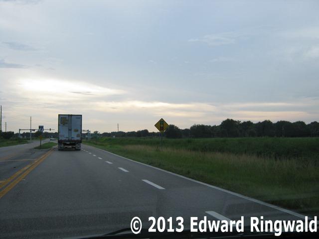
route markers change, and so on. But check out this goof from east central Pasco County, Florida just west of a town where it is famous for its
natural water, Zephyrhills. Look at the two route markers for Pasco County Road 54. Notice that the route is not
only going north, but it is also the start of the eastbound route of the same route. Sound confusing? 13: Interstate 5 northbound near San Clemente, California California, here I come! And I did, with my trusty digital camera during my 2007 trip
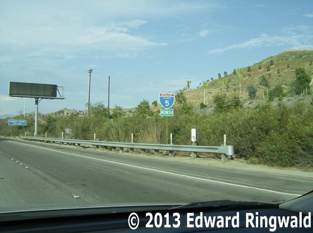
to Los Angeles. While I was there, I found some sign goofs courtesy of CalTrans, which is the California
Department of Transportation (California's equivalent of the Florida DOT). This one here can be found on northbound Interstate 5 near San Clemente and take a good
look: Look at the sign mounted directly below the Interstate 5 shield, the North cardinal direction sign. It is supposed to have a blue background as it is part of
an interstate highway. Instead, the cardinal direction sign is in white letters on a green background instead of the blue background the sign is supposed to be. Perhaps CalTrans should go back and review the MUTCD for what background color that should
be used on cardinal direction signs in relation to the route marker used. After all, the green background for the cardinal direction signs is for California's
'miners spade' state route markers while in Florida we use the outline of the great State of Florida in black on a while background using a square or rectangle
depending on how many digits the route number is; the cardinal direction signs are black on a white background that matches the route marker sign. 14: US 101, Hollywood, California Let's continue our California sign goofs adventure while we're out there. This next one is on US 101
southbound in Hollywood. California, that is. The home of the Dolby Theater and Oscar, the annual Academy Awards telecast. Look closely at the top left corner of the sign. Instead of a US 101 shield, there is an Interstate 101
shield mounted on a 'your tax dollars at work' sign. That's a no-no to begin with as you can't just go post an Interstate route shield anywhere you please. The only way you can have a limited access highway designated as an Interstate route is to first run your state DOT's
proposal to the American Association of State Highway Transportation Officials' (AASHTO) Special Committee on U.S. Route Numbering. If the route number gets this committee's blessing then it
has to be sent over to the Federal Highway Administration (FHWA), a component unit of the United States Department of Transportation, for their concurrent approval. Once both approvals are secured
then the Interstate route markers can be posted. 15: Interstate 5 south, San Diego, California Are we having fun in the Golden State in sunny Southern California? Great! Let's continue our California sign goofs adventure yet better, in sunny San Diego on Interstate 5 south. Take a look at the signage
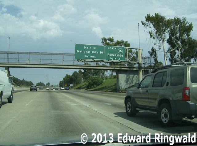
for Exit 13A, which is supposed to be California State Route 15 north to Riverside, not Interstate 15. Interstate 15 is signed as such north of Interstate 8 in San Diego. However, south of Interstate 8 the route changes from Interstate 15
to California State Route 15 and it's because of the same reason as we discussed in the previous photo of US 101 in Hollywood. Like I mentioned previously, CalTrans has to get not only the blessing of
not only AASHTO but the FHWA as well in order for the freeway grade route to be recognized as a part of Interstate 15. The next photo in the photo gallery shows you CalTrans' correct application of
the 15 route number: Until AASHTO and FHWA give their blessings - which was done with the eastern half of Interstate 295 in Jacksonville making it a complete beltway around the Jacksonville metropolitan
area - CalTrans can't recognize a freeway grade highway as an Interstate highway that fast. 17: USF Magnolia Drive in front of the Moffitt Cancer Center on the campus of the University of South Florida, Tampa Let's head back home to Tampa and to the main campus of the University of South Florida, home of the Bulls. College students. Calculus. Algebra. English Literature.
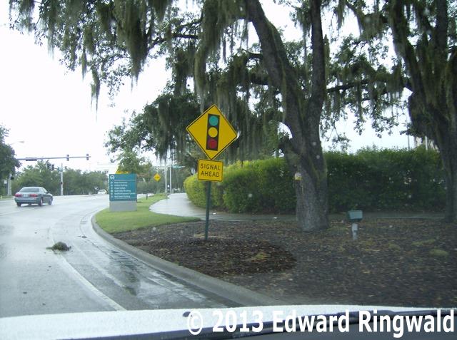
College of Health. College of Engineering. And sign goofs, like the one I found on USF Magnolia Drive in front of the Moffitt Cancer Center on the USF Campus. Look very closely at the signal ahead diamond warning sign. The correct vertical alignment of traffic signals is green on bottom, yellow in the middle
and red on top. Instead, the green is on top and the red on the bottom, akin to the signals you would see on CSX's A and S Lines. NOTE: This sign was recently replaced with the correct signage. 18: The City of St. Petersburg's Municipal Beach located at Treasure Island While the City of St. Petersburg does not front anywhere proper on the beaches of the Gulf of Mexico, there
is a beach access that is technically St. Petersburg territory within the City of Treasure Island. That is the City of St. Petersburg's beach access located on Gulf Boulevard
north of the Treasure Island Causeway and it features everything you need for the beach including dressing rooms and a concession stand among the items. And we can't mention the
wide sandy Gulf beaches.
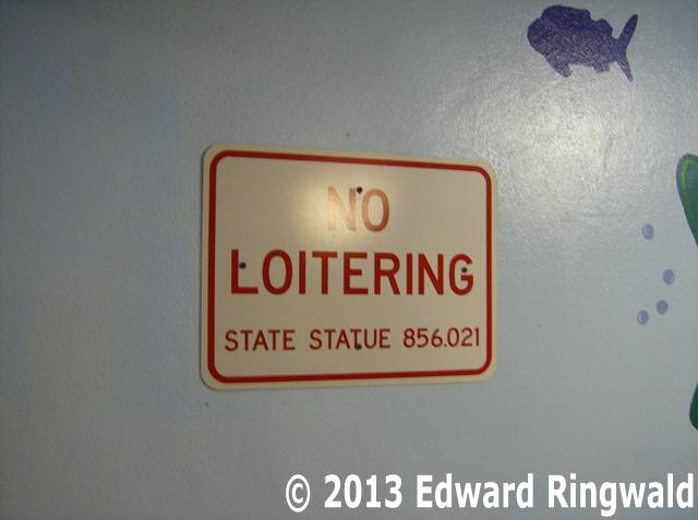
Take a look at this sign. Notice how the word 'statue' is misspelled as it is intended to mean
'statute' as in Florida State Statute 856.021 that outlaws loitering or prowling. Perhaps the sign makers over at the City of St. Petersburg's Stormwater and Traffic
Operations Department's sign shop should have reduced the font to FHWA Series C instead of using FHWA Series D in order to fit the word 'statute' onto the sign and
convey its exact intended meaning. By the way, a day trip to the beach here at the City of St. Petersburg's municipal beach at Treasure Island
makes for a good beach weekend. The meter fees are pretty reasonable and you can pay by credit card, as the parking area employs a pay and display system. 19: The Tierra Verde Bridge (FL 679) on the Pinellas Bayway, St. Petersburg It's the drawbridge that you cross in order to get to Ft. DeSoto Park, Pinellas County's southern
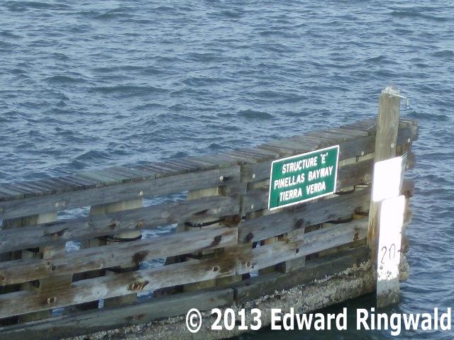
tip. However, being the only connection between Ft. DeSoto and the Pinellas County mainland traffic backups are quite common when the bridge is up. This sign goof I came across is mounted on the bridge fender for boaters to see. Look very closely at the sign;
it mentions on the third line Tierra Verda when it should actually read Tierra Verde. Doesn't the Florida DOT Sign Shop in Lake City have some kind of quality control
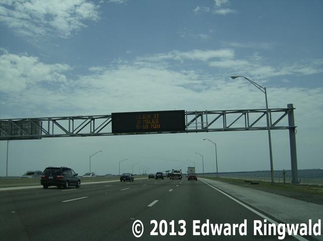
when it comes to making sure that the signs are spelled correctly? 20: The Variable Message Sign on Interstate 275 Southbound just past the Howard Frankland Bridge OK. Let's hop on southbound Interstate 275 across the Howard Frankland Bridge into St. Petersburg and the first overhead variable
message sign as soon as you exit the Howard Frankland. After all, these electronic signs tell us of travel times as well as accidents or road work ahead. Take a good look at this variable message overhead sign. It erroneously reads CLICK IT, 8 MILES, 8-10 MIN. Actually it should read on the
first phase CLICK IT OR TICKET and the second phase should have been GANDY BLVD 8 MILES 8-10 MIN. After all, you can only have two message phases on an electronic sign as motorists only have about 8 to
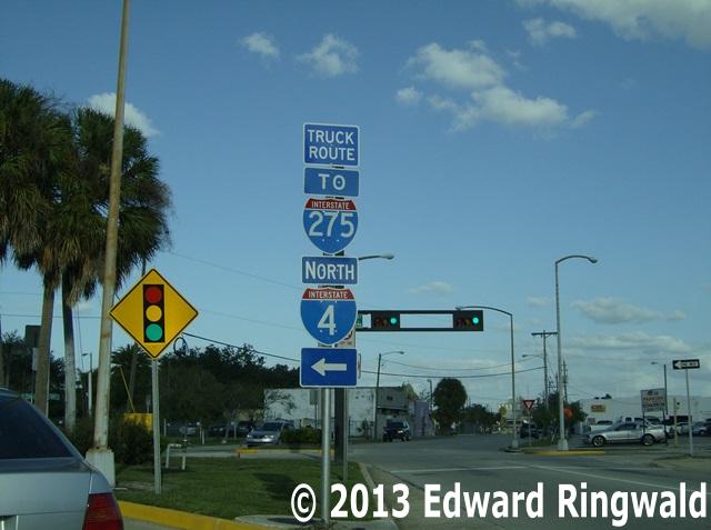
10 seconds to view and interpret the messages at 65 mph. 21: North Jefferson Street at East Cass Street, Downtown Tampa Let's drop into downtown Tampa for another sign goof I found! Look very closely at the directional signs for both Interstate 275 and Interstate 4.
The signage directs trucks onto North Jefferson Street - which turns into North Orange Avenue - for access to both interstates. The entrance ramps are organized
in that traffic for Interstate 275 uses the left entrance ramp while traffic for Interstate 4 uses the right entrance ramp. Also notice that there is
a direction sign just above the Interstate 4 shield, implying that Interstate 4 goes north rather than east. A recipe for confusion here. Perhaps the Florida DOT could put some clarification into this signage somehow. 22: Little Road (Pasco County Road 1) and FL 52, Port Richey Pasco County is Pinellas and Hillsborough County's northern neighbor. Pasco County Road 1 - known by
many names including Little Road - is part of a system of roads that includes Pinellas County's CR 611, also known as 49th Street in St. Petersburg. Besides, Pasco
County Road 1 provides an alternative to crowded and delay laden US 19. Take a good look at the signage for FL 52. The cardinal direction signage is meant for FL 52 but the signage
is mounted directly above the US 19 and Interstate 75 shields, creating yet another avenue of confusion. Neither US 19 or Interstate 75 are east-west roads; instead they are
north-south roads and FL 52 provides the connection to either road from Little Road. Perhaps Pasco County's public works department could correct this confusion somehow. 23: Chancey Road east of US 301, Zephyrhills While we're in Pasco County, let's head east over to Zephyrhills, home of its famous water that you can buy
at your local grocery store. (And it's better than tap water!) Take a good look at the diamond signal ahead sign to the right. The traffic signals depicted on the sign are
indeed mixed up: Green on top and red on the bottom. Sorry, that signal arrangement is for railroad signals; the signal arrangement for streets and highways according to the
Manual of Uniform Traffic Control Devices (MUTCD) is red on top, yellow in the center and green on the bottom. Just what part of the MUTCD doesn't Pasco County's public works
department understand? 24: Dale Mabry Highway at Kennedy Blvd., Tampa Let's head back south to Tampa and to one of Tampa's major intersections, Dale Mabry Highway and Kennedy Boulevard.
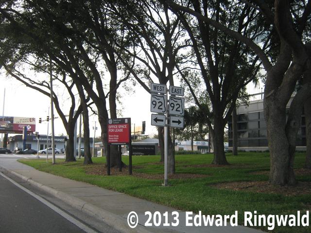
Dale Mabry Highway is the home of US 92 and Kennedy Boulevard - named after President John F. Kennedy who visited Tampa in 1963, days before that tragic day in November 1963 - is the
home of FL 60, the cross Florida state route from Clearwater Beach to Vero Beach. Now take a good look at the sign that is pictured. This sign is a big mistake on the part of the Florida DOT: Instead of
signing Dale Mabry Highway as US 92, it is signed as FL 92 instead! What is the difference between a Florida state route and an US route? 25: US 19 (34 St N) north of 38 Av N, St. Petersburg Let's head back across Tampa Bay to St. Petersburg, and this sign goof found on northbound US 19 just north of 38 Av N
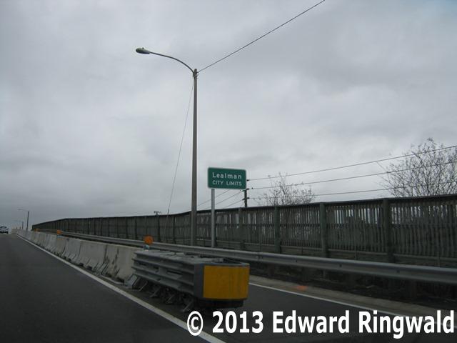
as it crosses the CSX Railroad tracks. This is by far the best Florida DOT goof to date and it was installed as part of a repaving and sign replacement project. You know that the community of Lealman is a piece of unincorporated Pinellas County situated between St. Petersburg and
Pinellas Park. Actually, Lealman is divided into two, West Lealman and East Lealman, as both are separated by Kenneth City. More and more people prefer to live in Lealman as it involves
paying Pinellas County taxes as opposed to taxes to a municipality as far as your city taxes are concerned. (Everyone in Pinellas County who owns a home pays the general Pinellas County
tax, but if you live in an unincorporated area of Pinellas County you pay what is called a Municipal Services Taxing Unit, which is Pinellas County providing the same services to you as
a municipality).
Now take a good look at the sign that got installed as part of the resurfacing project on US 19 (34 St N). Instead of
Lealman being all by itself on a green sign, it mentions that you are entering the City of Lealman. Lealman City Limits? OK, Florida DOT. Lealman is NOT a city, and the people of Lealman want to keep it that way. In fact, many Lealman residents
from time to time fight off any attempts by Pinellas Park for annexation. It's very simple: Your property taxes would go up if you became part of a city as opposed to unincorporated Pinellas
County.